|
|
Pisgah National Forest & The
Cradle of Forestry
Transylvania County, NC
"The Land of Waterfalls"
There are more than 250 waterfalls
of all shapes and sizes in this region of North Carolina.
Starting at the Pisgah NF ranger
station near Bevard, NC and working up US Highway 276 towards the Blue Ridge Parkway,
there are several nice hiking trails and waterfalls. The following represents only what we
found one Sunday afternoon.
 |
Lower Avery Creek Trail follows the
creek bed for the most part. Turn off Rt. 276 at the horse stable sign unto the forest
road. Approx. 1/2 mile past the stables is a trail leading down to the creek on the right.
There is a second trailhead just up the road, it is Upper Avery Trail and joins Lower
Avery Trail at the horse ford on Avery Creek. There are several waterfalls along the Lower
trail and a large cascade about a mile upstream from the horse ford (Upper trail). It is
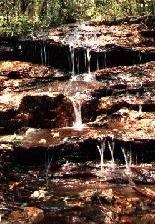
difficult to see from the trail and difficult to get down to the stream bed to see. There are several small streams that cross the Lower Avery
Trail with small waterfalls.
 |
This small waterfall is difficult to
get down to, but has a very nice knee-deep pool.
 Both Upper and Lower Avery Creek Trails are fairly level and easy,
once you get started. |
 |
|
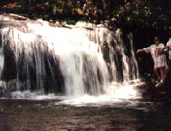
| Approx. 3 1/2 miles from the ranger
station is Slick Rock Falls. Turn unto forest road 475, then 475B. Approx. 1 mile to the
trailhead, a short walk to the falls. |
|
|
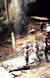
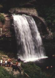 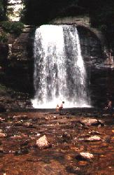 Looking Glass Falls, one of the most photographed falls in NC and the
most accessible. The first picture was taken from the road. A short path leads down to the
stream bed, a very popular place on hot days. Looking Glass Falls, one of the most photographed falls in NC and the
most accessible. The first picture was taken from the road. A short path leads down to the
stream bed, a very popular place on hot days. 65 feet high, 30 feet wide.
This is about 4 miles past the ranger station. |
| |
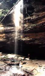  Next stop was Moores Cove Falls, 1 mile
north of Looking Glass Falls. This is a 50 foot falls, 3/4 mile off the road. It doesn't
have a lot of water going over it, about like a nice shower. There is a cave behind/under
it. Next stop was Moores Cove Falls, 1 mile
north of Looking Glass Falls. This is a 50 foot falls, 3/4 mile off the road. It doesn't
have a lot of water going over it, about like a nice shower. There is a cave behind/under
it. |
Also in the area is Sliding Rock. We
didn't have time to stop (and it was very crowded when we were there), but for $3 you can
slide down a natural water slide. Said to be the fastest 60 foot slide
|